Usually, I plan my travels well in advance, but this trip was a bit different. The idea was conceived a week before during a party with one of my friends and colleague. This time I wanted to give into the adventure of uncertainty(discretion is advised). As expected my better half was easily convinced and we started making a rough itinerary.
Meghalaya is one of the Seven Sister States of northeast India. Separating the Assam valley from the plains of Bangladesh, Meghalaya is mountainous, with stretches of valley and highland plateaus consisting mainly of Archean rock formations(4,000 to 2,500 million years old). Meghalaya is the wettest place on earth. The town of Sohra (Cherrapunji) holds the world record for most rain in a calendar month and the village of Mawsynram holds the record for the most rain in a year. Most of the rain fall occurs between June and September, creating impressive waterfalls and carving out some of Asia’s longest caves. Beginning of October is the best time to visit, to witness the waterfalls in full glory.
Meghalaya is home to three main ethnic tribes, namely the Khasis, Garos and Jaintias. A good time to be in Meghalaya is during the Hundred Drums Wangala festival in the Garo Hills. It is a post-harvest festival celebrated by the Garo tribe between October to December. Usually it is celebrated in the second week of November every year at Asananggre, a small Garo village 18 km from Tura in West Garo Hills.
Soon enough it was day one of our journey.
DAY 1(22/03/2016)
Three of us started out on our journey from Kolkata. We reached Shealdah railway station and boarded our train for Guwahati. The day was spent in the train.
DAY 2(23/03/2016)
We arrived at Guwahati raliway station at 04:15 AM, while it was still dark outside. We made our way to the adjacent parking lot and took a shared sumo to Shillong. It is about 100 km and took us around 3 hrs to get there. Shared taxis, Buses and private cabs are available on this route. A helicopter service is also available between Guwahati airport and Shillong Helipad.
For more information on Helicopter service: Gov of Meghalaya Transport Department - Helicopter Service
It was almost 08:30 AM and we had our breakfast and took another shared sumo from a parking lot in the Shillong Cantonment area, to Sohra(Cherrapunji).
Note: 10 people are accommodated in a shared sumo along with the driver. For comfortable journey one may pay for extra seats.
 |
 |
Shillong to Sohra is about 55 km and it took as around 2 hrs. We checked into our hotel, freshened up, had our lunch and booked a cab for local sightseeing. As we made our way through the picturesque meadows of Sohra towards Nohkalikai Falls, we could only imagine how lush green the meadows would be after the rains.
A nominal entrance fee is charged for the view point. Small shops are lined up one after the other by the side of the road leading from parking place to the view point. The tribal shopkeepers sell variety of stuff from local traditional craft items to locally produced bay leaves. Items made of bamboo and cane were cheaper here than in Shillong. Some shopkeepers offer hats and traditional dresses on rent.
Falling from a height of 1115 feet (340 metres) the Nohkalikai Falls is the tallest plunge type waterfall in India. There is a gruesome legend behind the name 'Nohkalikai' which in Khasi language means "Jump of Ka Likai". The legend is about a local women named Likai who jumped off the cliff next to the falls.
For more information on the legend : The legend of Nohkalikai
 |
 |
 |
Next stop was Ka Khoh Ramhah also known as Pillar Rock or Mothorp. It is also referred to as Giant Single Rock Shiva Linga(200 feet high). Legend has it that Khoh Ramhah is a fossilized cone shaped up side down basket of an evil giant who used to torment the locals. So in order to get rid of the evil giant, the people decided to invite him for a huge meal and mixed his food with sharp iron and nails which eventually led to his death. The giant basket that he had left at that place has turned into stone. On a clear day, the Bangladesh plains beyond are a sight to behold.
 |
 |
 |
On the way back from Khoh Ramhah, we stopped at Thangkharang Park. The park is apparently like any other clean and nicely maintained botanical garden. It is popular for its picturesque setting, with a fountain, greenhouse and garden. It offers a breathtaking panoramic view of the Bangladesh plains and the Kynrem Falls is also visible from this park.
 |
 |
Nartiang, a village about 22 km from Jowai, the district headquarters of Jaintia Hills and about 60 km from Shillong is famed for its Mawbynna Kper or monolith garden. Monoliths are scattered all around on Khasi and Jaintia hills. Monoliths are a symbol of remembrance. Vertical stones commemorate male members of the tribe and flat, horizontal stones commemorate female members. We did spot plenty of monoliths through out our journey through Meghalaya, but could not make time for Nartiang this time.
Note: Monoliths are a large single block of stone shaped like a piller. The tallest monolith(27 feet) is located in monolith garden of Nartiang.
 |
 |
Next we reached Mawsmai cave, just in time too as the daylight had already started fading. It is a limestone cave with Stalactites and Stalagmites. Due to the continuous dripping of water, it is mostly wet and has a damp smell. The cave is well lit for the tourist to enjoy the bewitching artwork of mother nature. It was a thrilling experience, to say the least and a fitting end to an eventful day.
 |
 |
 |
 |
 |
 |
DAY 3(24/03/2016)
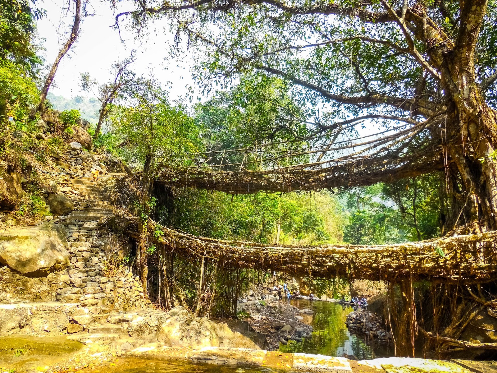
A trip to Meghalaya is incomplete without witnessing the fantastic man made natural wonders, the living root bridges. These living root bridges are unique in the world. They are hand trained from the aerial roots of Rubber Trees by the Khasis and Jaintias. They take about 15 years to complete and grows stronger with time. The most popular one is Umshiang Double-Decker Root Bridge.
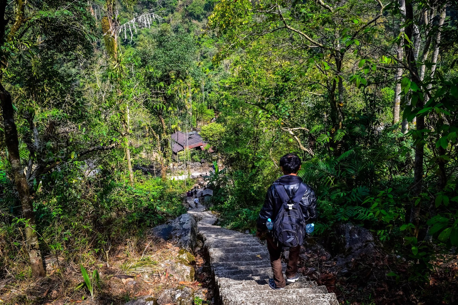
Early in the morning we finished our breakfast and took a cab to Tyrna Village. We took a cemented way down through the village and started our trek for the Umshiang Double Decker Root Bridge.
 |
 |
 |
 |
 |
 |
The path is marked with directions to the Double Decker Living Root Bridge. We took our time enjoying the beauty of nature and stopped at regular intervals to soak in the views.
 |
 |
 |
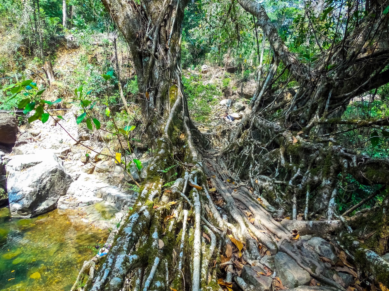
After trekking for about 2 Hrs we reached Nongthymmai village, which is almost at the half way point. This village is home to the Ritymmen Root Bridge. This bridge is 30 meters long, longer than double decker living root bridge(20 meters long).
Note: The longest living root bridge(over 50 meters) is located near the small Khasi town of Pynursla. It can be accessed from either of the villages of Mawkyrnot or Rangthylliang.
 |
 |
 |
 |
 |
 |
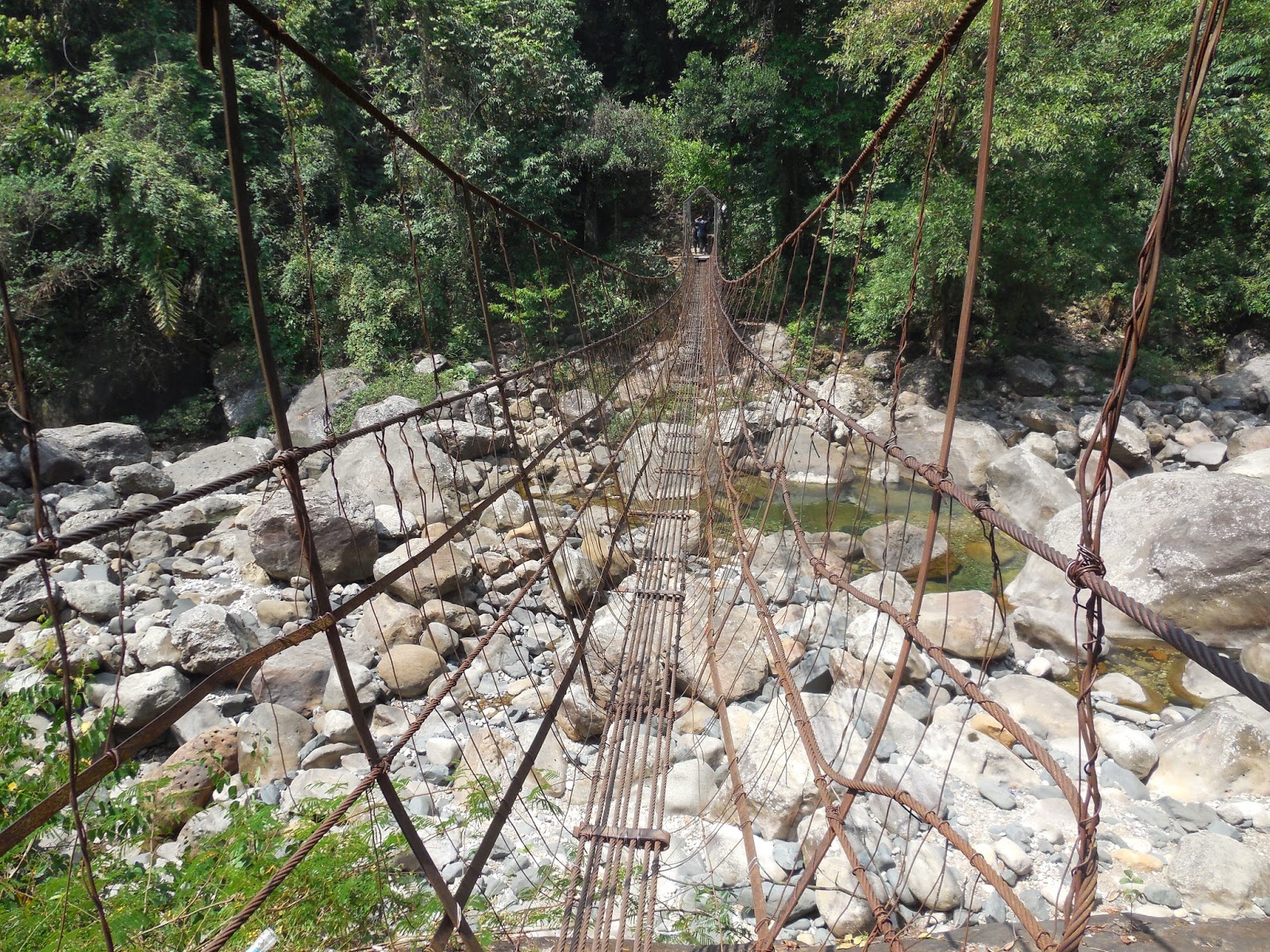
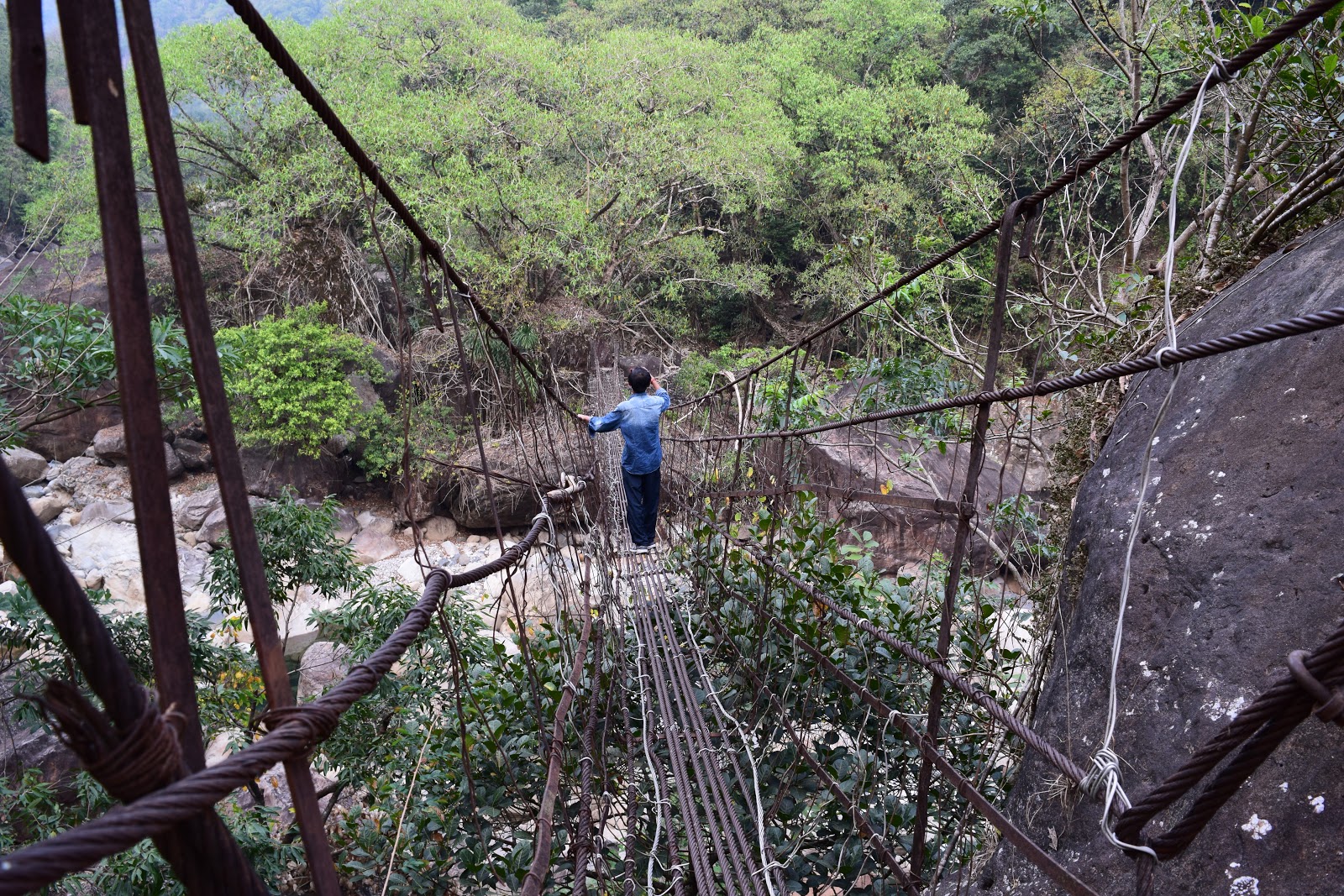
As we continued on our way towards Umshiang, we came across two suspension bridges made of rusty iron cables. The pristine blue water of the rain feed river flowing below the bridges will certainly draw anybodies attention. The bridges swing as one walks over it adding to the adventure. The second bridge is longer of the two.
 |
 |
After crossing these couple of bridges we had to climb some steep steps and cross a small root bridge in order to finally reach the Nongriat village, inhabited by Khasi tribe.
 |
 |
 |
 |
 |
 |
We made our way through the village to the much celebrated Double Decker Living Root Bridge. The bridge has two layers of root bridges, one above the other. Water from an adjacent waterfall flows below the bridge creating natural swimming pools. The water is crystal clear and fishes swimming in the pool is visible from some distance. All in all it is a sight to behold. We later learned that the lower level of the bridge was constructed initially but during rainy seasons the bridge used to get submerged in water. Hence, the second upper level of the bridge was constructed.
 |
 |
 |
There were two accommodations in Nongriat village. Serene Home-stay run by Byron and the Nongriat Guest House run by Challi. We had booked our stay in the Nongriat Guest House via call. After having a relaxing bath in the crystal clear pool water we had our lunch in the guest house and started exploring the area. We learnt that the Rainbow waterfall was another 3.5 hrs trek from here. Watched some kids playing football for a while in a small ground next to a Cemetery and then continued on the trail up to another iron suspension bridge.
 |
 |
 |
 |
 |
 |
 |
 |
On our way we came across sacks of dried bay leaves stacked at places by the side of the road or steps. The view from the suspension bridge was enthralling and was worth the effort. We turned back from here to get back to the Guest house before dark.
 |
 |
 |
 |
 |
 |
Once it was dark, we built a bonfire along with a guide accompanying another group staying at the guest house. The guide was friendly and entertained us with tails of his travels around the north east India. After dinner we made our way through the pitch black darkness with aid of torch light to the Umshiang. We sat there for a while listing to the sound of forest and returned back. It was a night to remember.
 |
 |
 |
DAY 4(25/03/2016)
Next morning we woke up with sore muscles, but had a long day ahead of us and had no time to relax. Soon after breakfast we cleared our dues and hiked back to the Tyrna Village. It was around 10:30 am in the morning and we took a cab to the garage near 'By The Way Hostel' in Cherrapunjee, where our bikes were to be there (Yai helped us in that regard. Yai runs a guest house in Cherrapunjee named 'D-cloud guesthouse').
We had to wait till 2 pm in the afternoon to get both our bikes(a Bajaj Pulsar 220 and a Yamaha R15). 25th March 2016 being Good Friday, all the restaurants were closed and we had a hard time finding food. Finally we started our ride towards Shnongpdeng, on a half empty stomach. In the joy of riding we forgot all our worries and soon we made our way past Mawkdok Dympep Valley View Point and turned right on to the AH-2 which runs till Dawki. This is indeed one of the most picturesque roads and best road trips in the country.
Daylight was already fading as we got the first glimpse of the Umngot River, famed for it's crystal clear blue water. We stopped for a few photos and moved on as we had to cover 10 km more to reach Shnongpdeng.
|
|


It was 8:30 pm when we finally reached Shnongpdeng. Our tents were ready by the Umngot river. A bonfire was lit for us close to our camps and food was served. As it was Good Friday non-veg food was not available and we were served simple vegetarian food including rice, daal and fried potato along with six boiled eggs. We were terribly hungry and gobbled the food up like there was no tomorrow.
DAY 5(26/03/2016)
 |
 |
 |
Once outside it felt like I was in the lap of mother nature. The experience was such that words and pictures can't do justice to it. I promised to myself that I will be back again in Shnongpdeng someday.
 |
 |
 |
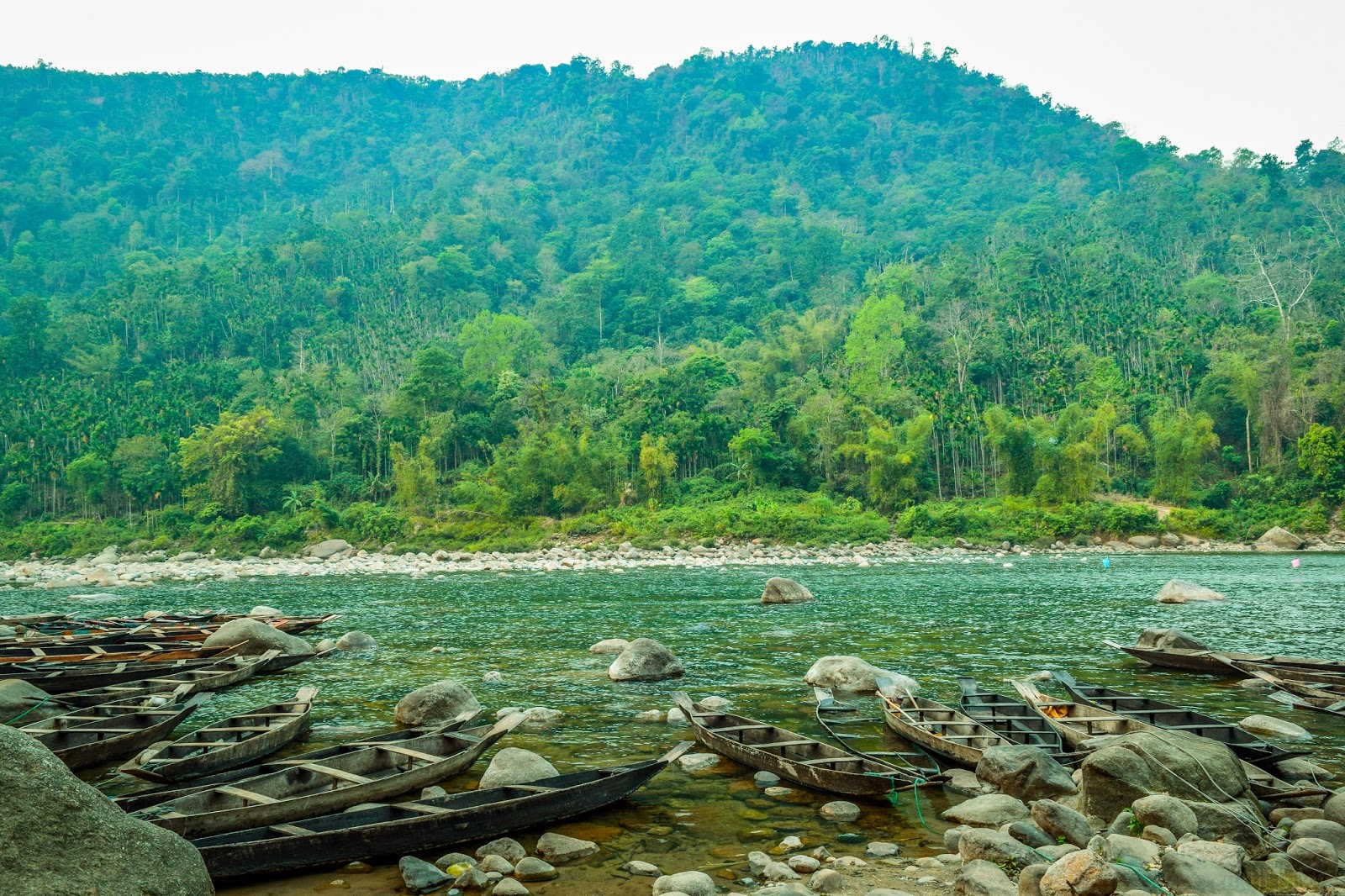
We started our ride back bidding adieu to Shnongpdeng, the idyllic village in Jaintia Hills by the Umngot River and reached Dawki. Stopped for a boat ride on the Umngot river, enjoying it's crystal clear water.
 |
 |
 |
 |
 |
 |
 |
 |
 |
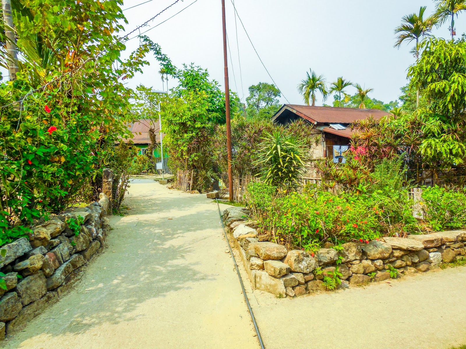
On our way back we detoured to Mawlynnong - 'Asia's cleanest village'. The travel magazine 'Discover India' has had declared the village as the cleanest in Asia in 2003, and the cleanest in India in 2005. The village pathways and courtyards were clean with flowering plants planted all around. Not worth the hype in my opinion but a nice little village none the less. The place was over crowded with cars and tourists, as tourists kept flocking in non stop and the real charm of being an idyllic village was lost.
 |
 |
 |
|
 |
 |
 |
Highlight of Mawlynnong was the food we had for lunch in Ha-La-Tyngkong Homestay cum Restaurant. The food felt like home cooked and we had our fill.
 |
 |
 |
 |
 |
 |
 |
 |
After the sumptuous lunch we hopped onto our bikes and started our ride back to Cherrapunjee with a stop at Mawkdok Valley. Dropped off our bikes at Cherrapunjee and got a cab for Shillong. Reached Shillong at around 09:00 pm and checked into our hotel.
DAY 6(27/03/2016)
It was our last day in Meghalaya and we started our day with a bit of shopping and checking out the wares in Police Bazar. Items made of bamboo and cane were cheaper in Cherrapunji.
Next stop was at Umiam Lake. Umiam Lake also known as Barapani lake is a reservoir created by damming the Umiam river. It is a vast and scenic man made lake that attracts a large number of tourists from across the country. Water sports complex at Umiam lake has a cafeteria for snacking, a photo booth to get oneself clicked dressed like a native and ticket booking counter for booking a boat ride or indulging in other water sports.
 |
 |
 |
 |
Next we stopped over at the Golf Links, a well maintained 18 hole golf course open to general public. It is a place for local people to relax on weekends.
 |
 |
 |
Next it was Ward's Lake, an artificial lake set amidst well-maintained lush botanical garden with orchids and other colorful flowering plants. The place includes a cafe for snacking and paddle boats are available for people who wants to do some boating in the lake.
 |
 |
 |
Our last stop was at Elephant Falls. It is a multi-tiered waterfalls in picturesque surroundings. It was named after an elephant like stone at its foot, which was destroyed in an earthquake. One has to climb down about 200 concrete steps to get to the bottom.
 |
 |
 |
 |
After our visit to Elephant Falls we got a shared sumo to Guwahati. Had our dinner and reached Guwahati railway station. Our train to Sealdah was at 10:45 pm from the station.
ROAD MAP
No comments:
Post a Comment